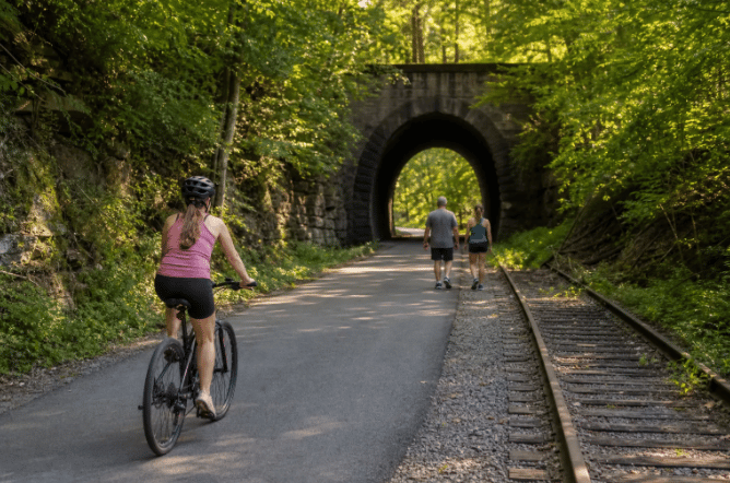
The Montour Trail runs 64.9 miles from Coraopolis in the north to Clairton in the south, tracing a former railroad corridor through Pittsburgh's south hills. Most of the route is crushed limestone; Peters Township has about four miles of asphalt, and Clairton adds another two. The grade is broadly flat, with a mild climb around miles 8–11 and some sustained grades on branch routes, which is exactly what you'd expect from a converted rail line. No specialized bike required, and no high fitness level needed to enjoy most of it.
The trail passes through Moon Township, Robinson Township, McDonald, South Fayette, Peters Township, Bethel Park, and Jefferson Hills before reaching Clairton. These are established residential communities, which is why the trail feels like a neighborhood asset rather than a wilderness expedition. A trail of this quality and length genuinely shapes how buyers think about where they want to live in Greater Pittsburgh.
Key takeaways
- Total system mileage: 64.9 miles including branches; the main route covers roughly 47–48 miles between Coraopolis and Clairton.
- Surface breakdown: Primarily crushed limestone throughout, with asphalt concentrated in Peters Township (4 miles) and Clairton (2 miles).
- Best family section: The paved Peters Township segment is the smoothest, most accessible stretch on the entire trail.
- Top anchor trailheads: Cecil Park (MP 22.6) and Peterswood Park (MP 32.9) offer the most complete facilities, including full restrooms. Note that Peterswood Park's bathrooms are approximately 0.25 mile from the trailhead via a side path.
- Active closure: The National Tunnel at mile marker 25 is closed indefinitely; check the trail website for current alerts before you go.
- Seasonal water: Drinking fountains operate early April through mid-October only.
What communities does the Montour Trail connect across Pittsburgh's SouthHills?
The main route follows the former Montour Railroad, a coal-hauling short line that ceased operations in 1984 and was formally abandoned in 1986. The Montour Trail Council purchased the right-of-way in 1991, and the first public segment opened in Cecil Township in October 1992. Because it was built as a railroad, the grade is broadly flat. The main exception is a mild, steady uphill stretch around miles 8–11; everything else rolls gently enough that most riders barely notice the elevation.
The trail connects to the broader Pittsburgh trail network at both ends. Near McDonald, the Montour Trail links to the Panhandle Trail via a connector that heads west toward West Virginia and east toward Carnegie. At the Clairton end, an approximately five-mile urban connector route reaches McKeesport, where it joins the Great Allegheny Passage. From there, the GAP connects to the C&O Canal Towpath, putting Washington, D.C. roughly 335 miles away for anyone with enough ambition.
Montour Trail branches and connector trails
The main route's 47–48 miles grow to 64.9 when you include the branches. The Westland Branch adds a gradual, sustained climb that challenges riders who've grown comfortable on the flat main corridor, it's worth the effort if you want elevation variety. The Bethel Park Branch is a short, accessible out-and-back well suited for families looking for a quick extension from the main route. The Peters Creek Branch rounds out the system with mostly crushed limestone and gentle grades, making it a natural add-on for riders who want extra mileage without changing surface conditions.
How long is the Montour Trail and what surface conditions should you expect?
Montour Trail distance and surface conditions
Miles 1–21 are the smoothest and flattest stretch on the entire trail. The first mile near Coraopolis is a bit rougher than the rest, so wide tires handle it better than road slicks. From there through McDonald and into Peters Township, crushed limestone dominates and the surface is predictable. The Peters Township section transitions to approximately four miles of asphalt, making it the firmest and most accessible portion on the route.
East of Peters Township, the picture changes. The surface mixes crushed limestone, asphalt, and on-road sections east of mile 39.5. The Library Viaduct crossing involves Route 88 with a narrow shoulder, which is not ideal for young children or first-time trail riders. The Clairton end includes about two miles of paved trail, but road crossings require real attention.
One closure worth knowing before you plan: the National Tunnel at mile marker 25 is shut down indefinitely due to concrete ceiling deterioration. The trail organization does not currently recommend an on-road detour because of narrow lanes and poor sight lines. Access the western side from McConnell Road (around MP 24.7) and the eastern side from the Kurnick trailhead (around MP 25.6). Check the Montour Trail's home page for current status before setting out.
Which section works best for biking, walking, or a family outing?
The continuous Coraopolis-to-Bethel Park corridor is the strongest choice for anyone wanting mileage without frequent stops or road crossings. The flat grade lets beginners build distance fast. Experienced riders can build long out-and-back rides on continuous limestone sections between Coraopolis and Bethel Park, and runners have an uninterrupted stretch with a consistent surface and minimal traffic crossings.
For families, strollers, or anyone with mobility considerations, the answer is the Peters Township paved section. It is smooth, firm, and easy to navigate at any pace. Cecil Park (MP 22.6) and Peterswood Park (MP 32.9) both sit near this corridor with full restrooms, more than 50 parking spaces each, water fountains, and picnic shelters. Keep in mind that Peterswood Park's full bathrooms are roughly 0.25 mile from the trailhead via a side path. These two trailheads are the most practical bases for a low-barrier family afternoon on the trail.
The eastern segments toward Clairton suit confident adults comfortable with brief road crossings. South Park connections add terrain variability that experienced trail users will appreciate, but that variability makes them a poor fit for anyone seeking the flat, predictable ride the Montour Trail is known for.
Where are the best Montour Trail trailheads and what facilities do they offer?
Montour Trail parking and access
Trailhead quality varies along the route. Many access points provide a few parking spaces; portable toilets are common but are often seasonal. Full facilities are concentrated at a handful of locations. Here are the main options for a first-time visitor:
Trailhead | Mile marker | Parking | Restrooms | Water | Shelter |
|---|---|---|---|---|---|
Montour Road, Moon Township | MP 0.0 | ~30 spaces | Year-round portable toilet | Fountain (seasonal) | Picnic shelter |
Galati Road | MP 21.2 | ~18 spaces | Year-round portable toilet | Fountain (seasonal) | Picnic shelter |
Cecil Park | MP 22.6 | 50+ paved spaces | Full park restrooms | Fountain (seasonal) | Picnic shelter |
Peterswood Park | MP 32.9 | ~50 spaces | Full bathrooms (~0.25 mi via side path) | Fountain (seasonal) | Picnic shelter |
Boggs Road | MP 11.4 | Yes | Year-round portable toilet; campsite nearby | Seasonal near campsite | Adirondack shelter at campsite |
Flush restrooms are the exception, not the rule. Cecil Park and Peterswood Park are the two locations on the entire trail with full park bathrooms, plan accordingly on longer rides. Drinking fountains operate from early April through mid-October, and portable toilets generally run March through November. Download or bookmark the interactive Montour Trail map at montourtrail.org before you leave home; the elevation tool on the maps page helps you preview grades before committing to a segment.
The Montour Trail is one of the best reasons to love living near Pittsburgh
For residents in Peters Township, South Fayette, Bethel Park, and the South Hills suburbs, the Montour Trail is not a weekend novelty. It is a permanent backyard amenity that shapes how people use their neighborhoods every day. A trail of this quality and length genuinely affects how buyers think about where they want to live in Greater Pittsburgh.
The Bingham Team works regularly throughout these communities and can advise on which neighborhoods give you practical, walkable or bikeable access to a trailhead, and which ones mean loading up the car just to get started. That kind of local context matters when you're weighing two houses that look similar on paper.
If you're exploring homes near the Montour Trail or anywhere in Pittsburgh's South Hills, reach out to The Bingham Team. We'll tell you exactly which neighborhoods put you close enough to matter.
Frequently Asked Questions
Do I need a special bike to ride the Montour Trail?
No, you do not need a special bike to enjoy most of the Montour Trail. Most of the route is crushed limestone and is broadly flat, so a regular hybrid or mountain bike is fine; only the first mile near Coraopolis is a bit rougher and wide tires handle it better than road slicks.
When are drinking fountains and portable toilets available on the trail?
Drinking fountains operate from early April through mid-October, and portable toilets generally run March through November. Full park restrooms are only at Cecil Park and Peterswood Park, while other sites rely on seasonal portable facilities.
Is the National Tunnel open for through traffic?
No, the National Tunnel at mile marker 25 is closed indefinitely due to concrete ceiling deterioration. Access the western side from McConnell Road (around MP 24.7) and the eastern side from the Kurnick trailhead (around MP 25.6) if you need to work around the closure.
Can you ride from the Montour Trail to Washington, D.C.?
Yes, you can connect from the Montour Trail to the Great Allegheny Passage and onward to the C&O Canal Towpath, which puts Washington, D.C. roughly 335 miles away. The Montour links to the Panhandle Trail near McDonald and to a connector toward McKeesport that joins the GAP.
Which sections should I avoid if I'm riding with young children?
You should avoid the Library Viaduct crossing and some eastern sections with brief road crossings if you have young children. The Library Viaduct involves Route 88 with a narrow shoulder and the Clairton end has road crossings that require caution, while the Peters Township paved section is the most family-friendly option.